July is birthday month for me and Rog. We started with a fun day with the family at Ryan and Beth's for taco lunch and swimming for Karissa. At the end of the month, Ryan ad Beth drove us up to Tahoe (!) for our annual lunch at Jake's.

Sandwiched between these two birthday celebrations was Roger's hike on the 170 mile Tahoe Rim Trail.
My Experience While On The Tahoe Rim Trail, 2022
(Note: Roger counted only hiking days while Sue, the photo editor, included zero days in the count. So the photos may have a different Day # than the narrative.)
I had attempted the Tahoe Rim Trail the year before with my Grandson, Max. I woke during the first night of the trip with heart palpitations and was forced to back out. Max, at the time, decided to continue around the lake as I drove back and forth, Rocklin to Tahoe, in support. He was able to complete the trip around the lake making all of us very proud of this huge endeavor.
As the year passed, Sue pledged her support at another attempt by me to complete the 170 mile hike around the Tahoe Rim Trail. If she could meet wherever the road crossed the trail for food and water supplies maybe it would be possible. More planning, revisions of hiking distances, and where to stay were all considered for the new agenda.
Pre day 1-3: Sue and I camped for three days at the Campground at the Lake at South Lake Tahoe, a nice campground just across the street from the beach at South Shore. I did some hiking, trying my best to acclimatize to the altitude. With Starbucks as a destination, I did a five mile round trip hike for a cup of Joe one morning.

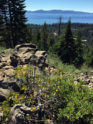
Day 1, 10.9 mi, Kingsbury North to Genoa Peak Road: Sue dropped me off at the Kingsbury North trailhead located just above the casinos near the stateline by 6:30am. I had decided to shorten the first day a bit from what Max and I had done. One, because it was a lot of mileage the first day, and two, there is no camping at Trailhead Spooner. I made pretty good time passing the well known “Bench”, about half way, by 10:30. The weather was perfect, in the 80s with a cool breeze. I didn’t see anyone much (three squirrels and a handful of birds) until I got to the bench and shared some time with three young locals (bicyclists) while I rested up a bit on the Bench. Yes, there really is a bench that someone carved out of some logs and set into the rocks at the high point with a wonderful view of the Lake. By 12:40 I was back on trail heading for my destination.
I arrived at Genoa Peak Road by 1:00 with 10.9 miles under my belt for the first day. Water was a little heavy with a planned liter per five miles plus a liter for dinner and breakfast as well as water to get me to Spooner Summit the next day, 3 miles up trail, where Sue would resupply. I set my lean-to for the night and was all set in camp by 2:00. I saw a few people pass camp and was able to chat a bit. Two girls went by heading to Bench, asked about the trail, but I didn’t have the heart to tell them they had a long and slow climb up the mountain. I managed to eat dinner although trail hunger definitely hadn’t set in at this early point. Another handful of bikes stopped by for a quick chat and they were off. One fellow came by and stayed for a bit to catch up on rest. He was from Tennessee and had done a lot of trails throughout the US. I knew it was a bit early but decided there wasn’t much left to do so I headed into my sleeping quarters, a bivvy with sleeping bag and air mattress inside. Good thing I set up the shelter with one side facing the wind. I was in a little corridor that really blew throughout the night. The altitude does affect me a little. The doctor said it is fluid build up around the heart. Not to worry, just makes me a little out of breath trying to get to sleep.

Day 2, 12.4 mi, Genoa Peak Road to Marlette Lake: The birds start to chirp just at the first sign of daylight, 5am. I was up, started packing, ate breakfast and was ready to go by 6. It was an easy hike, just a few miles to Spooner Summit to meet up with Sue. On the way I saw my first real wildlife, a beautiful buck strolling up the hill away from my direction. Sue met me at the trailhead for breakfast with water supply, goodies to snack on while underway on the trail, and the meals I would need to get me to the next resupply. After a great meeting, it was time to head out for the remainder of the day’s hike, just five more miles, so I thought. The body was still going pretty strong, not too many sore muscles but there were a few aches here and there. All the exercising leading up to this hike is paying off.
My next destination was Marlette Lake. The plan was to avoid carrying loads of water (2 lbs per liter) so I would detour off the trail (1.5 mi) and drop down to the lake for water and a night’s rest. I was to discover that the creek I had relied on was so overgrown it was near impossible to access and there was less than a trickle of water. I decided to make my way to the lake to find water. Along the way, I could hear a trickle running through a pipe under the dirt road. Ah, I was able to collect water, run it through the filter, and now I was set for the day/eve/morning. As I approached the lake there was a sign that said no camping in Marlette basin. I realized later that camping wasn’t prohibited in the area, but rather that there just wasn’t any clear spot to set up a camp. The hike to my camp spot was a killer that led straight up a road that was at an angle that maxed out my ankles. It was in the hot afternoon sun and lasted for a mile and a half. Whew. At an excruciatingly slow pace I did manage to make it to the top of the hill and set up camp right next to the “no camping beyond this point” sign. A few mountain bikers came through, stopping at the top of the hill, which gave me a little company for the eve. Dinner once more and an early bedtime.


Day 3, 11.1 mi, Marlette to Tunnel Road: It is getting to be routine to get up just as daylight is starting to break and pack. This is followed by retrieving my Bear Canister, a big plastic barrel that contains all smellable items to keep the bears at bay, then breakfast, throw on the pack and off I went, destination Marlette Campground and back on the TRT. Little did I realize I had another one mile stretch, again straight up, before rejoining the trail. I did finally make it to the campground where I met a couple of ladies out for their first test run for a possible future hike around the lake. Jamie and Rae-Lyn were full of laughter and great to spend some time with. The campground had bear boxes, tables, and even a pit toilet complete with TP. The real attraction of this place was the hand pump at a well that was a hundred yards down the hill from the campground. Once run through the filter, the water was quite cool and refreshing. It was said the water was good to drink right out of the pump but that it had an odd taste, hence the need to filter. After the rest I was off to Tunnel Road, the next camp spot on the trail. I managed to see lots of people along this stretch and was able to chat with a lot of them. This day was filled with lots of downhill switchbacks. The intersection of TRT and Tunnel Rd was an open area where the bicycles and hikers would stop for a rest before moving on. This gave me plenty of opportunity to chat with people helping to occupy the afternoon/ evening. The body is getting tired but the muscles are still holding out pretty well.
Bear Visit: I had hit the sack about 8 and got at least an hour of sleep in before I was woken with a big crash. It was my Bear Canister being checked out by a huge bear. He started to work over the canister. In the dusk, a PCT hiker came into camp (Shadow). I yelled “BEAR!” and he saw that my canister was being tested. We yelled, screamed, threw rocks, trying everything possible, not wanting to have the bear chase us but rather go away. We ended up sort of watching in the darkness as the bear picked the canister up in his front paws, stood up and slammed it to the ground, wacking it around, clawing at it, trying to destroy this box of food. He worked on it for a good two and a half hours as we could just make out movement in the dark. Suddenly, without any knowledge on our part, the bear had managed to get behind us and took off running up the hill into the woods. Needless to say, there wasn’t much sleep that night on my part. The next morning I found my canister after about a half hour of searching, a good 100 feet away from where it had first started. It was covered in bear snot and dirt with just a few scratches on it, but still intact. It worked, I will still be able to eat.


Day 4, 9.7 mi, Tunnel Road to Tahoe Meadows (Mt. Rose campground): This was to be an easy day, about 8 miles. Unfortunately, it felt like a hundred after no sleep. Also in that short distance was a climb of about 1,000 feet. I did make it but I was at the end of the line. Exhausted, beat, and sleepy, I arrived at the van and stated that I quit. In fact I was going to quit everything, karate, aikido, gym, walks from the car to the store. I was going to take up permanent residence in my big cushy chair at home and drink beer for the rest of my days. Lucky for me, Sue was a little more reasonable and suggested I take a zero day (day off with no miles), see how I felt, then make the decision. This day off, spent at Mt Rose Campground really made a big difference as I caught up on sleep, rested, ate real food, and decided I would give it another go.

Day 5, 13 mi, Mt Rose to Gray Lake Turnoff west: After a day of rest I think I finally started to find my pace, I called it sloth mode. This was a day I wasn’t looking forward to. I had to climb to the highest point of the TRT, Relay Peak, 10,400 feet. I was looking forward to Galena Falls, a great water stop and a beautiful waterfall that cascaded down the hillside, helping to relieve me of some weight to that point as I collected water to last until the spring at Gray Lake. Although I was moving at such a slow pace I was able to make pretty good time. I made it to the summit at 10:50, declaring myself King of the Mountain, but unfortunately the Yosemite fire had filled the Tahoe Basin with smoke. I couldn’t even see the outline of the lake. Oh well, I was able to put my hand on the boulder that was at the highest spot on the mountain. The flies were a bit thick so there wasn’t much time to dawdle. I met Zoey as she passed in the opposite direction and suggested she hook up with Sue back at Mt Rose campground for a place to stay. We had shared our camp spot with Britney the night before. On my way off the summit I was able to chat with three young hikers doing the circuit in the opposite direction. It turned out that Napman, Rooftop, and Mermaid were from Meadow Vista, living in the same neighborhood as our old haunt. Small world. I later found the spring where Brintney caught up with me and we shared some cool spring water while we both “cameled up”. She still had some steam left and headed out while I went a short hike down the trail to the Gray Lake trailhead and set up camp. A couple came by and were trying to decide if they would make the mile hike to the lake for water or not. I told them about the spring, and how to find it. They were real happy to hear about the spring and were off with smiles. I was about to doze off for the night when a couple of guys came jogging by camp. They didn’t see me but they did spot my canister in the bushes. They were curious and started to investigate when I spoke up saying that it belonged to me. It startled both of them to find a person camping. All was just fine, they thought it might be a Geo-cash.
A word on the Bear Canister. I knew to put it away from where I sleep, I guess that is obvious, but I hadn’t thought to hide it. After this, I started putting the canister under brush, in hollow tree trunks and under logs. In fact, after looking at several good spots around my camps I almost forgot which spot I used the next morning. This led to placing sticks as arrows with rocks stacked to tell me the next day where to look.


Day 6, 13.3 mi, Gray Lake to Brockway Summit: I was awoken during the night by the full moon. It looked like a giant searchlight coming through the trees. I have also learned to check out the wind before setting up camp. A lot of the time the wind will whistle over or through a section and by moving just a few feet one way or the other you can avoid most of it. Gray Lake camp spot was a great location, not too many carpenter ants (you learn to live with them) and a very restful night. I was up early as usual, packed, ate breakfast, had coffee and once again hit the trail. Just another long day of hiking. This day included my first lost moment on trail. I tried the apps on my phone but they were worthless. I checked my map, it helped a bit. I finally took my best guess hoping it was right since I was headed downhill. It would be a long, slow, miserable hike back if my calculations were wrong. The trail had no markers which really made me question where I was. Finally an older couple came by and confirmed I was on the TRT. I was so relieved. I met many more great people along the way giving me moments to stop and catch up now and then. The final run was a long downhill stretch (out of sloth mode and into high gear) ending at the parking lot at Brockway Summit. I was greeted by my lovely wife for more supplies and a night of sleep in the van. That afternoon we drove to downtown King’ Beach and sat in the Safeway lot, drank beer, and ate ice cream, and wow lasagna for dinner. Later we headed down the “Fiberboard Freeway”, a tiny road with a great little offshoot where we could park for the night, right at the TRT.


Day 7, 11.8 mi., Brockway Summit to Fiberboard Road: We woke way before daylight as Sue made me a great breakfast and got me on the trail at daybreak. The trail started out with a lot of downhill helping out immensely with warming up those tired muscles. I was later to pay for all that nice downhill with some hard climbing before the day was out. My destination was another dry camp which involves carrying more water (more weight) so it was a bit of a slow go. I stopped by Watson Lake, a beautiful little lake nestled in the woods. I took a pretty long break there before continuing on. I had passed some of the best views of Lake Tahoe along the way, very inspiring. Adding to the beauty were the clear skies, smoke free. I made it into camp at Fiberboard Road fairly early and set up camp. Fiberboard Road is the same road that Sue and I had stayed the night before if you remember. I hiked 11.8 miles just to get back to a different section of the road. Weird. This was another resting spot for bikers so I was able to chat with them as they rested up for their next run. One asked what it was I desired when I reached town. I think it is pretty universal, the answer being cold beer, juicy hamburger, and ice cream.


Day 8, 12.3 mi, Fiberboard Road to Tahoe City: There was a bit more uphill in this stretch than I had expected but I managed just fine. The old body is still holding out at this point, but tired. I was able to keep to the usual schedule of breaking up camp and being on the trail by 6am. I coasted down the last half mile of trail into Tahoe City and met Sue waiting at the trailhead. Our schedule was off kilter since I took an extra zero day at Mt Rose so our camping spot was unavailable. We drove home for my day off where I spent a day drinking beer and sitting in my cushy chair munching on a hamburger.
Zero day…….


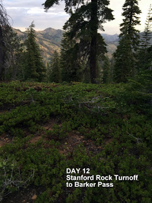
Day 9, 13.7 mi, Tahoe City to Stanford Rock: My plan was to make it to Ward Creek, a good hike out of Tahoe City. I faced an ascent of about 800 feet and back down in order to get to Ward Creek. It was a tough climb since the ascent was to be done within a couple of miles. I got a little misplaced on my hike, but luckily, just as I was about to travel down a steep slope a young couple came by with knowledge of the area. After asking if I was on the TRT they directed me back about 15 minutes from whence I came where I found a faded TRT sign, completely white from sun bleach, someone had penciled in a little arrow and the letters TRT. I had missed it the first time through. I arrived midday at Ward Creek, found a little clearing right near the water/foot bridge, managed to replenish my water supply and soak my feet in the water getting ready to settle in for the evening. Two ladies came by, they had hiked the TRT some 18 years ago. I directed them to the little path that led down to the water and the three of us squeezed into a tiny hole in the bushes where we soaked our feet and chatted while sitting shoulder to shoulder. “Froggy” was 84 and “Cuucuu” was 81. They said they didn’t have all the amenities that the trail has now, there were no bridges back then. They were quite an inspiration to me. Once they were gone I was faced with the long afternoon and eve trying to recuperate from the hard day’s hike. I sat in my chair, cameled up, while watching a gopher pop out of his hole a few feet away and haul green grass down into his little home. Then it hit me. Why not try to put in another five mile to get a jump on the next day? I threw everything into the old pack, slapped on the old back, and was on the trail once again. This had various results. The trail went straight up with lots of rock stairs built into the trail to fight erosion. Some stairs are 16 to 20 inches tall as either a giant built them or some idiot that has never had a pack on his back. I swore I would find that sadistic creature and torture him, but I climbed on. Through exhaustion I found Stanford Rock trailhead with a very nice open space, perfect for the night’s camp. A quick camp set up and into the sack. I woke just before midnight, first with quiet foot steps real near. I shined my flashlight only to find a deer walking calmly about ten feet from me. About a half hour later I woke to a light coming through the trees down the path. It hesitated a moment at the Stanford Rock trail then continued on the TRT : a night hiker.


Day 10, 9.4 mi, Stanford Rock to Barker Pass: I woke to mosquitoes. Covered up with long sleeves and long pants I quickly got out the mosquito net for my head. This was a great set up for the wee bugs. I made it to Barker Pass, yet another tough hike although better than the day before, with a lot less of those horrible stairs. Sue met me at Barker Pass where I gave her a big birthday hug and once again exchanged water, food, and a few clean clothes. We were able to spend quite some time together. Barker Pass had a couple of tables, and an outhouse although no toilet paper. I thought there was water there but to no avail. Sue and I took the car down to the lakeside and hit up the little grocery across from William Kent for a gallon of water. Then we went up for a nice visit back at Barker Pass. A couple of ladies came by that I had met on the trail earlier so we had great conversation as we shared our picnic table and we all ate our lunch. Sue had brought a great tasting taco salad and finished it off with some oreos. It was hard saying goodbye but we managed as I set up for the night in a small meadow right there. Later in the evening a couple of PCT hikers came by, so it was fun talking with them as one stayed on to consume his 4,000 calories per day dinner before moving on at dusk to hike another ten miles before calling it a day. It wasn’t too lonely that night with all my little mosquitoes standing guard around my netted bag throughout the night. The next stretch was the longest with no resupply of the trip, Three nights….

Day 11, 9.4 mi, Barker Pass to Richardson Lake: Off I went to Richardson Lake with an early wake up call from my wee friends. Richardson Lake was picturesque. Plenty of room to set up camp. I shared the afternoon with four PCTers, Netherlands, Poland, Canada, and US. Then it was quiet as they moved on. I thought I was going to be alone for the night as late afternoon came around, but then people started to roll in. By nightfall there were over a half dozen of us, one coming in after dark, to share the area. I slept pretty good until about 3 in the morning when I heard a big crash, like a tree falling, or a big branch breaking, then silence. Then it started again. The sound of the rumbling through the woods was evidently a bear. I heard him come close to camp but never set eyes on him as I heard the crashing pass by. Oh well, time to get up, pack and eat for yet another day.


Day 12, 13.2 mi, Richardson Lake to Dick’s Lake: The plan was to hike from Richardson Lake to Fontanillis Lake, but I was struck by another late inspiration and pushed on late in the day. But first, let’s back up to the beginning of day 12. The trail had a lot of downhill sections on this day making the hiking pretty good. But to make up for the nice hiking, I think I timed my hike to coincide with a huge mosquito hatch. They were literally in clouds. Thank goodness for the head net as I think I would have been breathing the little monsters. This lasted for four hours of forced hiking as I tried several times to stop for water only to look down at my gloved hand to see it totally black with mosquitoes, two layers deep. It was exhausting though, after the four hours, they suddenly were gone. It was about that time that someone passing made a snide comment on my head net only to be answered with, “You’ll wish to hell you had this thing in about five minutes”. The trail to Fontanillis ended with a steep uphill climb with lots of those dastardly stairs to climb. It about did me in. The lake was beautiful with a full stream emptying out right at the trail. I looked around, trying to figure where the trail went from there but to no avail. I checked the map but couldn’t decipher which direction. I had found a nice little spot to set up camp but it was still early in the day. I finally came across a fellow who was hiking the opposite direction around the TRT and asked where he had come from. He showed me the trail he had come in on so now I was well oriented. Again, after some rest, soaking of feet, and gathering of more water, I got one of those inspirations to travel the short distance to Dick’s Lake. It was hard but always worth taking some mileage away from the next day. Dick’s Lake was another picturesque lake with easy access for more water. The mosquitoes seemed to be present so I headed a little bit up the hill away from the water’s edge finding a great little camp spot. I now hid the bear canister at night after learning my lesson but found it hard to find in the morning as I had looked at several spots before deciding on the final hiding place. I now put up a stick in the ground along with arrows laid out with sticks to indicate the spot I had hidden the canister. One last marker, three rocks piled and pointing to the hiding spot making recovery easy the next day.


Day 13, 14.3 mi, Dick’s Lake to Tamarack Lake: The next morning I was faced with yet another climb, Dick’s Pass, elevation 9,380 ft. I was now used to going at sloth speed on the uphills. Dick’s Pass was different than the others as it wasn’t a sharp peak but rather a kind of rolling flat top. It did have a great view of the back country as I passed over the summit. The rest of the day was filled with lots of downhill hiking. It was a bit difficult since the trail turned from nice soft dirt to cobbles of all sizes. It was very much a hunt and peck sort of hike as I tried to stay vigilant with the constant threat of twisting an ankle. Not out here! Chatting with people along the trail I was warned about the crowds that come in for the weekend at Tamarack Lake. I was tempted to hike into another spot but stuck to my plans as I entered the Tamarack Lake area. I found a little clearing but it looked to be infringing on a big group of campers, so I went over and chatted with them for a bit. It was a family of 25, all ages, and a very interesting group. It was their second annual gathering at this spot. After chatting for awhile it turned out they were from Penryn, Loomis, Newcastle, and Auburn. Pretty cool. They were gracious enough to allow me to camp close by. More soaking of feet in the lake, eating dinner, setting up camp, and hiding the bear canister, then off to slumberland.


Day 14, 15.3 mi, Tamarack Lake to Shower’s Lake: I was told that Tamarack Lake had a 5am bear on a regular basis so after packing, I started my hike without breakfast. The trail was again a continuation of the cobblestones as I headed toward Echo Lake and Echo Lake Lodge where I was to meet up with Sue and Michelle for resupply and pick up Michelle for an overnight partner. It was only a few miles of hiking but I was surprised with how much uphill was snuck into this section of trail. Echo Lakes hold their own with beauty although it was evident what the fires from last year had done. The cabins alongside the lake looked to be saved with small green patches outlining each one. I finally rolled into the lodge area and was greeted by Michelle and big hugs. Then Sue met us in the parking lot where we resupplied, ate, and headed off to finish the hike to Shower’s Lake. Michelle and I did some hard hiking with some challenging uphills. We hiked through the devastation from the fires and then some, managing a late arrival at 6 in the evening, quite pooped. We found a great spot to camp although once again we had been warned of the crowds. Yes, there were quite a few people but very respectful and quiet. No mosquitoes in the evening but a few by morning.


Day 15, 8.7 mi, Showers Lake to Big Meadow/Grass Lake: Michelle kept up with me with a great pace that matched my own. I was able to hike at my own pace with great company. This leg of the trip saw the southernmost point of the trail at the intersection that left the Pacific Crest Trail. We hiked past Round Lake and on to Big Meadow. We were able to drop our packs in the parking lot and wait for a short while until Sue and Dan made it there. Once again, resupply, water, and this time a change of partners as Dan joined the hike for the last two legs of the journey. I had already put my miles in for the day so Dan and I went about a mile up the trail and established camp there for the night. Dan brought out a surprise treat at camp. He set up his stove with a steamer pot and steamed fresh cucumber, mushrooms, and green beans with just a little pinch of salt. This was followed up with Gouda cheese and slices of salami, all enjoyed with a tiny box of red wine. Now this was camping.


Day 16, 13.1 mi, Grass Lake to Star Lake: This day was to be a real challenge (as if none of the rest were). We faced 9.5 miles of uphill climbing about 2,000 feet with about a mile of downhill to make Armstrong Pass. Then a three mile uphill to climb about a thousand feet to pass over Freel Peak. That second section really took a toll. Finally, after reaching Freel Peak, we had a couple of miles of downhill to reach Star Lake. Whew! Star Lake was pretty green with algae so we were concerned about filtering the water. We were a little short of water since we had thought Star Lake would be a source, but we rationed ourselves and made do. We could replenish at a stream about a mile into tomorrow’s trek. Upon arrival we stripped down to our skivvies and jumped in. It felt sooooo good. The cool water seemed to suck the aches and pains right out of me. After our swim, Dan broke out the stove once again to steam fresh vegetables, enjoy the cheese and salami, and toast to our accomplishment of the day.
That night I had set up in the usual manner with a tarp on the ground and me in my bivvy. Some time during the night I woke up to the pitter patter of rain drops. I quickly hopped out of bed to shuffle stuff around and throw the tarp over the top of me and my stuff to keep dry. Rain never came but the pitter patter woke me once more before our early morning departure.


Day 17, 10.3 mi, Star Lake to Kingsbury South: Our final day. We were up a bit earlier in order to get a good head start on the day. We were packed, ate breakfast and enjoyed our coffee just as the daylight was bright enough to put away the flashlights. The Last Day. The Final Hike. It was mostly downhill for this last section but always, downhill is interspersed with some uphill sections just for the challenge. We were coming upon the California/Nevada Border when we came across Froggy and Cuucuu, my two eighty year old friends from Ward Creek. They too were finishing up their hike around the lake. I introduced them to Dan, we all hugged and took pictures as we exchanged e-mail addresses and said our goodbyes. They declared that they were my personal trail chicks and on we went. Dan and I faced a few raindrops along the way as we started to pass more and more ski lifts on the back side of Heavenly Valley. We made our way to the final trail leading off the Tahoe Rim Trail that led to the trailhead at Kingbury South. We were greeted by Sue with open arms as I made those final steps before dropping the pack, changing into clean clothes, and heading off for that much dreamed of Big Fat Hamburger…..


No comments:
Post a Comment